
Rain continued to exit Southern California on Monday, allowing authorities to lift all evacuation warnings and orders that had been issued near recent burn areas due to concerns over mudslides and debris flows.
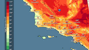
According to the National Weather Service, clouds are expected to linger for another day, along with a slight chance of light showers, particularly along the Central Coast. Any rainfall is expected to remain minimal, with totals under one-tenth of an inch.
Forecasters said conditions should improve by mid-week, with dry weather expected from Wednesday through the weekend. By Wednesday, the weather system is forecast to move far enough south to reduce cloud cover and keep rain south of Los Angeles County.
Temperatures are expected to rise beginning Friday as a moderate Santa Ana wind event develops. By Sunday, highs could run three to six degrees above normal.
With the threat of heavy rain diminishing, officials reopened Topanga Canyon Boulevard between Pacific Coast Highway and Grand View Drive, a stretch known for mudslides. The roadway will remain closed nightly from midnight to 5 a.m. as crews continue repairs related to damage from last winter’s storms and the Palisades Fire.
Despite improving weather conditions, the Los Angeles County Department of Public Health issued a beach advisory urging residents to avoid all water contact—especially near storm drains, creeks, and rivers—through at least 8 a.m. Thursday due to potentially elevated bacteria levels. Inner Cabrillo Beach in San Pedro remains closed until further notice following a sewage spill on Christmas Day.
Residents are encouraged to monitor storm updates and emergency information at lacounty.gov/emergency or sign up for alerts at alert.lacounty.gov. Evacuation updates are also available through the Genasys Alert app or at genasys.com.


Leave a Reply